


2017-01-25.gpx

georgein
User
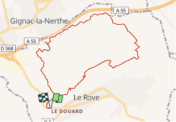

Length
11.1 km

Max alt
265 m

Uphill gradient
387 m
Km-Effort
16.3 km

Min alt
84 m

Downhill gradient
387 m
Boucle
Yes
Creation date :
2019-08-04 09:23:49.973
Updated on :
2020-01-31 20:35:36.21
--
Difficulty : Unknown

FREE GPS app for hiking
 SityTrail
IGN / Geographical institutes
SityTrail Plus
The world is yours!
About
Trail Walking of 11.1 km to be discovered at Provence-Alpes-Côte d'Azur, Bouches-du-Rhône, Le Rove. This trail is proposed by georgein.
Positioning
Country:
France
Region :
Provence-Alpes-Côte d'Azur
Department/Province :
Bouches-du-Rhône
Municipality :
Le Rove
Location:
Unknown
Start:(Dec)
Start:(UTM)
681271 ; 4803913 (31T) N.
Comments